The U.S. Stock Market: Best and Worst Performing Sectors in 2022
Top Heavy: Countries by Share of the Global Economy
Ranked: The 100 Biggest Public Companies in the World
Ranked: The 25 Countries Receiving the Most U.S. Immigration Visas
All of the World’s Money and Markets in One Visualization (2022)
Timeline: The Most Important Science Headlines of 2022
Mapped: The Most Innovative Countries in the World in 2022
Visualizing the World’s Top Social Media and Messaging Apps
Visualized: FTX’s Leaked Balance Sheet
The Shrinking Trillion Dollar Market Cap Club
Visualizing $65 Trillion in Hidden Dollar Debt
Ranked: The World’s Wealthiest Cities, by Number of Millionaires
U.S. Inflation: How Much Have Prices Increased?
Visualizing Currencies’ Decline Against the U.S. Dollar
Mapped: Which Countries Have the Highest Inflation?
Visualizing the Composition of Blood
Visualizing the Relationship Between Cancer and Lifespan
Explainer: What to Know About Monkeypox
Visualizing How COVID-19 Antiviral Pills and Vaccines Work at the Cellular Level
Mapped: The Most Common Illicit Drugs in the World
Visualizing 25 Years of Lithium Production, by Country
Visualizing EV Production in the U.S. by Brand
A Visual Crash Course on Geothermal Energy
Explainer: The Science of Nuclear Fusion
Mapped: Global Energy Prices, by Country in 2022
Mapped: The Population of India’s States Compared with Countries
Mapped: Which Countries Have the Highest Inflation?
All of the World’s Spaceports on One Map
Map Explainer: The Caucasus Region
Mapped: The 3 Billion People Who Can’t Afford a Healthy Diet
Visualizing 25 Years of Lithium Production, by Country
Ranked: The World’s Largest Copper Producers
All the Metals We Mined in 2021: Visualized
Visualizing the World’s Largest Iron Ore Producers
Mapped: The 10 Largest Gold Mines in the World, by Production
A Visual Crash Course on Geothermal Energy
Ranked: The World’s Top Cotton Producers
Visualizing Mismanaged Plastic Waste by Country
Visualizing Changes in CO₂ Emissions Since 1900
Interactive: EV Charging Stations Across the U.S. Mapped
Published
on
By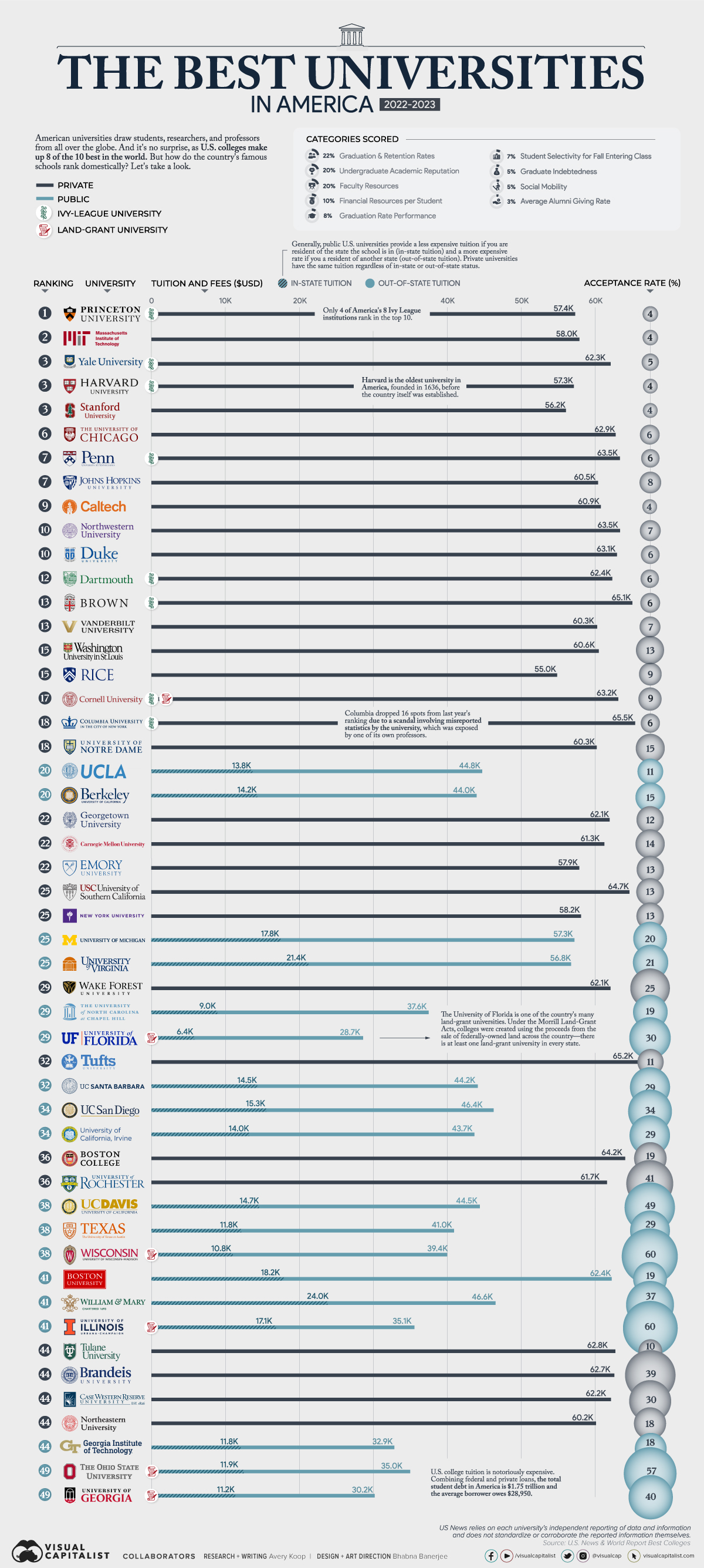


The United States is home to many world-class universities like Harvard, Princeton, and Yale, which boast innovative research programs, famous alumni, prestigious awards, and students and faculty from all over the world.
But which schools are actually the best ones in America?
This ranking uses data from U.S. News & World Report to rank America’s 50 best universities from the Ivy League to public institutions. Additionally, this visual shows the average tuition and acceptance rate of each school.
Here’s a look at how different categories are scored in the ranking. It is worth noting that U.S. News relies on each university’s independent reporting of data and information and does not standardize or corroborate the reported information themselves.
How categories are weighted:
Ivy League universities are often assumed to be the top schools in America, but in reality, only four of the eight make the top 10.
Here’s a closer look:
One of the Ivies, Columbia University, actually dropped 16 spots from last year’s ranking due to a scandal involving misreported statistics by the university, which was exposed by one of its own professors. There have been critiques of the U.S. News & World Report ranking since, as it doesn’t provide a uniform set of standards for the universities, but lets them determine how they score their categories themselves.
Among the top 10 schools admittance is very competitive, and none of the acceptance rates surpass the 7% mark. Massachusetts Institute of Technology (MIT), Stanford University, and Caltech are among the most difficult universities to get into, with only 4% of applicants receiving that exciting acceptance letter. On the flip side, the universities of Illinois and Wisconsin, for example, accept 60% of all applicants.
A few more things to know—there are eight private schools in the U.S. that have earned the distinction of “Ivy League,” due to their history and prestige. A number of schools are also classified as land-grant universities—built on land which was essentially given to them by the U.S. government. This was in an effort to provide higher education to lacking communities across the country, and there is at least one in every state.
These are the U.S.’ eight Ivy League Institutions:
Beyond these prestigious academies, there are many high caliber institutions like The Ohio State University and the University of Wisconsin—both of which are land-grant universities.
Among the top 50, there are another four land-grant universities:
There is ripe controversy, however, surrounding land-grant universities, as, in many cases, the U.S. government funded these institutions through expropriated indigenous land.
U.S. college tuition is famous for being unaffordable. Combining all the federal and private loans in the country, the total student debt comes out to $1.75 trillion and the average borrower owes $28,950.
Here’s a look at how tuition breaks down on average:
The most expensive school in America is Columbia University, with the cost of admission coming out to a whopping $65,524, with some estimates showing even higher rates for the 2022/2023 academic year. The least expensive among the top 50 is the University of Florida at $6,380 for in-state tuition—more than 10x cheaper than Columbia.
But many Americans may soon see their college loans forgiven. The Biden administration’s initiative to cancel student debt will roll out any day now and will be available on federal loans for select qualifying individuals. It has the potential to provide 40 million people with as much as $20,000 in debt forgiveness.
And given that American universities make up eight of the 10 best universities in the world, perhaps the price tag will be worth it.
Visualized: Who Americans Spend Their Time With
Animated Map: Where to Find Water on Mars
The Rising Cost of College in the U.S.
The Top 100 U.S. Colleges, Ranked by Tuition
The Impact of International Students on the U.S. Economy
Chart: Which Universities Have the Richest Graduates?
How Much Student Debt Does Each State Hold?
Which College Produces the Most Billionaires?
Where does each river start, converge, and end? This series of maps traces river basins in each continent around the world.
Published
on
By
There are hundreds of rivers on Earth’s surface, moving freshwater from hills and mountains down to larger rivers, lakes, and oceans.
Thanks to the planet’s natural slopes and ridges, falling rain that isn’t absorbed by soil or evaporated also ends up in nearby rivers. This area—where all flowing surface water converges—is called a river basin, drainage basin, or watershed.
These maps by Adam Symington show the world’s many rivers and major river basins, using the HydroSHEDS database and broken down by continent.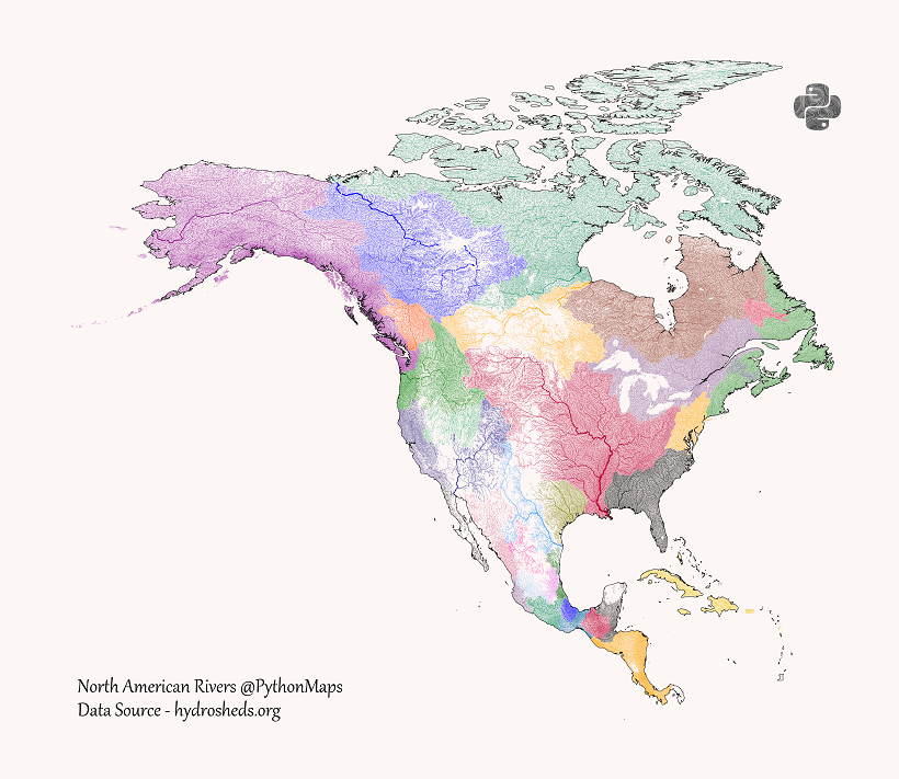
North and Central America have many different river basins, but a few major rivers stand out.
To the North, Canada’s Mackenzie River runs from British Columbia through the Northwest Territories and ending up at the Arctic Ocean.
Of course, the Mississippi River and the Missouri River which flows into it both stand out as well, draining water from much of the U.S. to the Gulf of Mexico.
A few rivers and basins also start in the U.S. and end up in Mexico, including the Rio Grande from Colorado to Tamaulipas. Further south in Central America and the Caribbean, most of the basins don’t have major rivers and empty into the nearby oceans.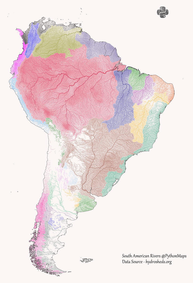
It’s well-known that the Amazon River is the largest river in the world by volume and the second largest by length.
Likewise, its reach and impact can be seen in these maps. The Amazon basin is the largest river basin in the world with an area of 6,300,000 km², covering just over one-third of the entire South American continent.
That is almost double the sizable Río de la Plata basin, the 5th largest river basin in the world, which includes the Uruguay River and the Paraná River and meets at the border between Uruguay and Argentina. 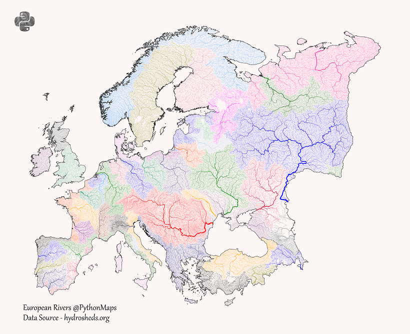
Despite being the second smallest continent, Europe’s proximity to many different bodies of water and great variation of terrain in small areas gives it many different drainage basins.
But a few notable rivers stand out in Central and Eastern Europe. The Danube, a historically important trade route and once a frontier of the Roman Empire, originates in Germany and flows eastwards to the Black Sea, passing through 10 total countries.
The longest river in Europe, the Volga in Russia, is also the cornerstone of the continent’s largest river basin, draining into the Caspian Sea. Its tributaries include the Moskva which runs through Moscow in Western Russia before flowing eastwards.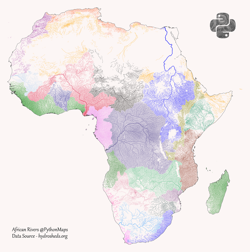
One of Africa’s most notable features is the lack of drainage in the Sahara Desert. But the continent also has a few clear major river systems, including two of the world’s largest rivers.
In the northeast, the Nile River is the world’s longest river, flowing from Lake Victoria and Lake Tana in the south to Egypt and the Mediterranean Sea. In total, its basin covers 11 countries.
In Central Africa, the Congo River (formerly the Zaire River) is the second largest river in the world by volume. It also is central to the Congo Basin, the second largest river basin with an area of 4,014,500 km².
And in West Africa, the Niger River creates a crescent shaped basin from the Guinea Highlands, northeast to Mali, then southwest through Niger and Nigeria. It ends in the massive (and massively important and populated) Niger Delta.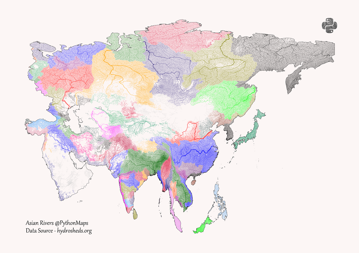
The world’s largest continent also has one of the largest varieties of river basins. From large sweeping basins in North Asia, to deserts in mountainous Central Asia and the Arabian Peninsula, to the multitude of basins draining into the Indian Ocean.
One of the major standouts is the Yangtze in China, the world’s third-longest river and largest plastic emitting river. Flowing from the Tibetan Plateau to the East China Sea, its wide basin covers one-fifth of China’s land area and one-third of its population.
The largest by volume is the Ganges–Brahmaputra–Meghna system, three major rivers running through India, China, Nepal, and Bangladesh. Their combined basin is home to around 400 million people, making it the most populous river basin in the world, ultimately draining into the Ganges Delta and ending up at the Bay of Bengal.
But the largest river basins in Asia are those of the “great Siberian rivers,” the Ob, the Yenisei, and the Lena, which all flow north to the Arctic Ocean.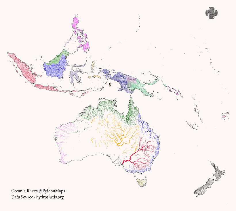
Comprised of many archipelagos and islands with a high ratio of coast along the Pacific Ocean, Oceania understandably has fewer long rivers and major river basins.
But there are still a few standouts, especially in the deserts of Australia. The Murray–Darling basin in the country’s southeast includes six of Australia’s seven longest rivers (including the namesake Murray), draining west to the Southern Ocean near Adelaide.
Towards the center of the country is the Lake Eyre basin, which covers 1,210,000 km² or just under one-sixth of the country’s landmass. This mostly flat and often dry basin drains into Lake Eyre, Australia’s largest lake, which only fills up with water about four times a century.
If you want to see higher resolution versions of these maps and do more river exploration for yourself, head to the PythonMaps Twitter. For full-size prints, check out the PythonMaps Etsy.
Timeline: The Most Important Science Headlines of 2022
Our Top 22 Visualizations of 2022
Visualizing $65 Trillion in Hidden Dollar Debt
Ranked: The 25 Countries Receiving the Most U.S. Immigration Visas
Visualizing 25 Years of Lithium Production, by Country
The Future Value of Disruptive Materials
Ranked: The 100 Biggest Public Companies in the World
Visualizing Currencies’ Decline Against the U.S. Dollar
Copyright © 2022 Visual Capitalist